GREEN BAY, WI (WTAQ) - Folks in northwest Wisconsin will get relief Thursday night from a heat wave that’s been around since last weekend.
The rest of us, though, will have to wait until Friday night for things to cool down.
The National Weather Service says a cold front will arrive Thursday evening in northwest Wisconsin, and will sweep southward across the state Friday.
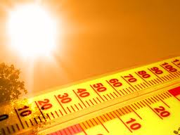
Until then, afternoon highs in the 90’s and heat indices in the 100’s will continue to be the norm.
Boscobel in Grant County had the week’s highest heat index Wednesday at 109.
Green Bay set a new record Wednesday for the warmest overnight low for the date at 75. Milwaukee and Wausau tied similar records.
Madison had just under an inch of rain in a half-hour late Wednesday afternoon.
Spotty thunderstorms are in the forecast statewide for Thursday.
Rusty Kapela of the Weather Service calls this a normal summer heat wave – nothing like the gripping heat of a year ago, when it was in the 90’s for over 20 days. Still, officials say folks should not brush this off.
Milwaukee officials urge people to check on neighbors who are elderly or live alone – don’t leave kids and pets alone in a hot car – and find public places to cool down if necessary.
Heat advisories continue until 9 p.m. Thursday in northwest Wisconsin, until 5 p.m. Friday in central and northeast areas, and until 7 p.m. Friday in the rest of the state.